Sokkia, a subsidiary of Topcon, has expanded its portfolio of surveying, positioning and reality capture technology, including new total stations, GNSS receivers and handheld scanning systems.
“The latest additions to the Sokkia portfolio reflect the increasing need for connected workflows across surveying, mapping, construction and infrastructure projects,” said Neil Vancans, head of Topcon Geomatics Sales. “The technologies support users in collecting, processing and transferring data through a common workflow from field operations to office-based design and project delivery.”
GNSS Receivers: GCX5 and GRX7
Designed to provide real-time positioning data for projects ranging from topographic surveys to corridor and infrastructure, the new GCX5 and GR7 GNSS receivers support RTK positioning through the Topnet Live correction network.
The receivers include anti-jamming and anti-spoofing capabilities and support tilt compensation of up to 60 degrees. They can be used in environments where canopy cover, structures or terrain may affect satellite visibility.
Georeferenced data collected with either receiver can be integrated into downstream surveying, mapping and construction workflows. The receivers are available in configurations designed to meet varying project requirements and budgets.
SokkiaShared Reality Portfolio and Handheld Scanners
Sokkia also launched a new Shared Reality portfolio, which supports reality capture and the creation of 3D point cloud data for surveying, mapping, construction and infrastructure applications.
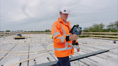
The portfolio includes the new SRS1 and SRS2 handheld scanners.
The SRS1 mobile laser scanner is designed for single-operator data collection. It can be used in a handheld, front-pack, backpack, vehicle-mounted and UAS-integrated operation configurations.
It is ideal for infrastructure, urban mapping, construction, forestry and other geospatial applications, the company says. Data collected with the SRS1 can be processed and transferred through Magnet Flow and Magnet Bridge for integration into CAD and BIM workflows.
The SRS2 handheld scanner is designed for mobile data capture in environments with limited features or reduced positioning availability. It uses SLAM (Simultaneous Localization and Mapping) technology that combines multiple localization inputs to generate a positioning trajectory during scanning.
Manual Total Stations: iM-60 and iM-120
The iM-60 and iM-120 manual total stations are designed for survey and construction applications, including controlling networks, layout, monitoring and as-built verification.
Observation data can be transferred to CAD and BIM workflows, reducing manual data entry and helping maintain data consistency between field and office operations, says Sokkia.

 machineryasia
  Sokkia