Hurricane Beryl Floods Roads Across the U.S., Downs Northeast Bridges
Crews across the U.S. are still cleaning up the mess left by Hurricane Beryl, which made landfall Monday morning near Matagorda...
 machineryasia
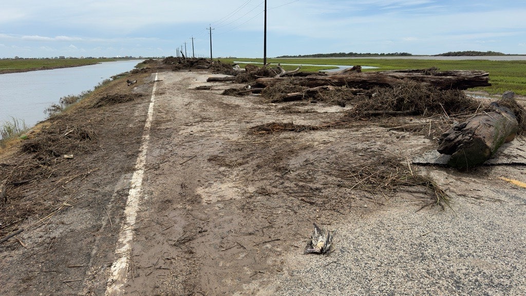
Crews across the U.S. are still cleaning up the mess left by Hurricane Beryl, which made landfall July 8 near Matagorda, Texas.
Beryl was the earliest-forming Category 5 hurricane ever recorded in the Atlantic Ocean, according to the World Meteorological Organization, and was at major hurricane intensity near Jamaica and the Cayman Islands at its peak. Beryl was a Category 1 hurricane when it reached the U.S. coast.
Windspeeds in Matagorda reached 80 mph and East Texas was hit with storm surges and torrential rain, according to the National Oceanic and Atmospheric Administration.
A July 9 Facebook post from the Texas Department of Transportation showed crews preparing to clear roads and repair traffic lights.
The Texas DOT’s website as of July 10 showed two areas near Houston — near Alvin to the southeast and East Bernard to the southwest — were still marked as having likely flooding.
Twelve deaths tied to the hurricane have been reported so far – 11 of which are in Texas, according to media reports. Reuters reported July 11 that 1.5 million Texans remained without power after Beryl destroyed power lines across eastern Texas.
Northeast Flooding, Downed Bridges
As the remnants of Beryl moved northeast, areas in New York, Vermont and New Hampshire were hit with heavy rains and flash flooding.
As of July 11, parts of northern Vermont and New Hampshire remained under a flood warning from the National Weather Service and the New England 511 website showed dozens of road closures in the area.
The Weather Channel reported July 11 that seven bridges in Vermont had been taken down by flooding and one person died.