Deployment of Epiroc digital safety solution in production mines
LKAB is deploying a high-precision digital safety system in its Swedish mines to improve personnel tracking, communication, and emergency response. www.epiroc.com LKAB, a major mining operator in northern Sweden, is upgrading the safety infrastructure at its Kiruna and Malmberget underground sites. Historically, the company relied on a zone-based tag system that provided estimated locations of personnel within specific sectors. To increase safety standards and operational visibility, LKAB required a more precise, high-resolution solution capable of providing real-time data on the movement of both staff and machinery. The primary objective of this technical transition is to shift from zonal estimation to exact location tracking. This digital transformation aims to reduce emergency response times, improve traffic safety, and streamline navigation across complex underground networks. Technical features of the real-time location system LKAB selected a comprehensive digital suite designed for mining environments, utilizing existing Wi-Fi and mobile networks alongside a sophisticated tagging system. The solution was chosen for its ability to integrate several critical functions into a single interface: High-Level Tracking: Real-time monitoring of personnel and vehicles via mobile devices and tags. Targeted Communication: The ability to send automated, zone-specific safety alerts or evacuation notices directly to employees' work phones as they enter high-risk areas. 3D Spatial Awareness: A 3D mapping interface, accessible on smartphones and in-vehicle displays, which visualizes the mine's topography and critical assets. Deployment and operational support The implementation is characterized by a collaborative development model between the technology provider and LKAB. The solution is being refined through on-site testing in real production environments, allowing for continuous feedback loops. The system is currently being rolled out at the Kiruna mine, while regular field testing has commenced at the Malmberget site. The deployment includes a mobile application that mirrors control-room data, providing workers with autonomous access to navigation support and emergency information. Safety and efficiency benefits The transition to a digitalized smart building system for underground mining yields several objective operational improvements: Emergency Management: Central control rooms can now issue mass emergency messages and receive acknowledgments from workers, providing real-time status updates during evacuations. Navigation and Logistics: The 3D mapping system simplifies the location of rescue chambers and equipment, reducing downtime associated with navigation in expansive underground galleries. Collision Avoidance: In-vehicle modules display potential traffic hazards and collisions on a digital map, increasing safety for heavy machinery operators. According to Hans Wahlquist, the project demonstrates the potential for digital transformation in the mining industry by moving toward a more integrated and smarter operational model. By replacing passive tags with active digital modules, LKAB establishes a coordinated response framework for crisis scenarios and daily production alike. Edited by Evgeny Churilov, Induportals Media - Adapted by AI. www.epiroc.com Powered by Induportals Media Publishing
 machineryasia
LKAB is deploying a high-precision digital safety system in its Swedish mines to improve personnel tracking, communication, and emergency response.
www.epiroc.com
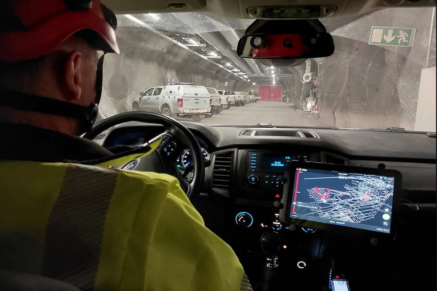
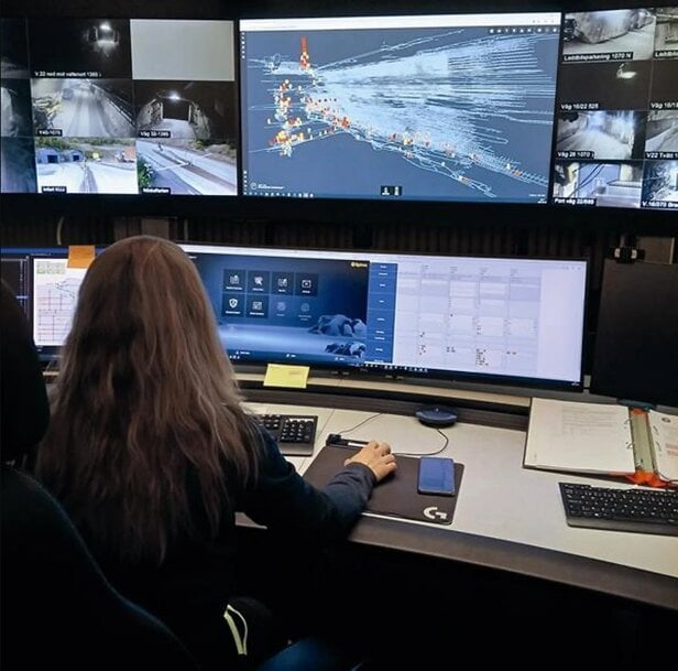
LKAB, a major mining operator in northern Sweden, is upgrading the safety infrastructure at its Kiruna and Malmberget underground sites. Historically, the company relied on a zone-based tag system that provided estimated locations of personnel within specific sectors. To increase safety standards and operational visibility, LKAB required a more precise, high-resolution solution capable of providing real-time data on the movement of both staff and machinery.
The primary objective of this technical transition is to shift from zonal estimation to exact location tracking. This digital transformation aims to reduce emergency response times, improve traffic safety, and streamline navigation across complex underground networks.
Technical features of the real-time location system
LKAB selected a comprehensive digital suite designed for mining environments, utilizing existing Wi-Fi and mobile networks alongside a sophisticated tagging system. The solution was chosen for its ability to integrate several critical functions into a single interface:
- High-Level Tracking: Real-time monitoring of personnel and vehicles via mobile devices and tags.
- Targeted Communication: The ability to send automated, zone-specific safety alerts or evacuation notices directly to employees' work phones as they enter high-risk areas.
- 3D Spatial Awareness: A 3D mapping interface, accessible on smartphones and in-vehicle displays, which visualizes the mine's topography and critical assets.
Deployment and operational support
The implementation is characterized by a collaborative development model between the technology provider and LKAB. The solution is being refined through on-site testing in real production environments, allowing for continuous feedback loops.
The system is currently being rolled out at the Kiruna mine, while regular field testing has commenced at the Malmberget site. The deployment includes a mobile application that mirrors control-room data, providing workers with autonomous access to navigation support and emergency information.
Safety and efficiency benefits
The transition to a digitalized smart building system for underground mining yields several objective operational improvements:
- Emergency Management: Central control rooms can now issue mass emergency messages and receive acknowledgments from workers, providing real-time status updates during evacuations.
- Navigation and Logistics: The 3D mapping system simplifies the location of rescue chambers and equipment, reducing downtime associated with navigation in expansive underground galleries.
- Collision Avoidance: In-vehicle modules display potential traffic hazards and collisions on a digital map, increasing safety for heavy machinery operators.
According to Hans Wahlquist, the project demonstrates the potential for digital transformation in the mining industry by moving toward a more integrated and smarter operational model. By replacing passive tags with active digital modules, LKAB establishes a coordinated response framework for crisis scenarios and daily production alike.
Edited by Evgeny Churilov, Induportals Media - Adapted by AI.
www.epiroc.com
Edited by Evgeny Churilov, Induportals Media - Adapted by AI.
www.epiroc.com
Powered by
Induportals Media Publishing