Terrestrial Laser Scanners for Real-Time Reality Capture
Leica Geosystems introduces the upgradeable RTC series to accelerate 3D data acquisition and field-to-office collaboration at a scalable investment cost.  leica-geosystems.com The launch of the all-new Leica RTC series — comprising the RTC300, 500, and 700 models — marks a major advancement in terrestrial laser scanning by combining high-speed data capture with industrial-grade precision. As modern surveying, engineering, and infrastructure projects face compressed schedules and expanding data volumes, transforming physical assets into precise spatial models requires rapid, automated workflows. This technology ensures that physical site metrics are immediately digitized and fed directly into the enterprise's digital supply chain for asset management and construction orchestration. Scalable Performance Architecture and Hardware Integration The new RTC series is designed to replace the existing Leica RTC360/LT and ScanStation P30/P40/P50 product lines, bridging the gap between the rapid scanning speed of the RTC360 and the structural robustness of the P-Series. This unified hardware platform delivers a 35% increase in data accuracy compared to its nearest market competitor, making it highly versatile for applications across surveying, industrial plants, public safety, and infrastructure projects. A core feature of the RTC series is its upgradeable platform design, structured into three distinct performance tiers. Through this tiered scalability, engineering teams can purchase the specific performance level that matches their current project requirements and budget constraints. Furthermore, the system supports on-demand upgrades; as data complexity or range demands grow, users can transition to a higher performance tier via software-enabled unlocks, entirely eliminating the capital expense of replacing physical hardware. Real-Time Cloud Collaboration and Livelink Connectivity Beyond raw hardware metrics, the RTC series transforms data sharing from a sequential process into a continuous, real-time workflow. This shift is driven by Livelink, an industry-first capability integrated into the Leica Cyclone FIELD 360 mobile application. Livelink automatically streams point cloud data directly to the Hexagon GeoCloud as it is captured by the sensor. This cloud-connected ecosystem allows multiple laser scanners on a single job site to feed data into a unified, shared project simultaneously. Field crews and office-based BIM managers can visualize the registered data in real time, enabling them to identify and resolve data gaps or shadow zones before leaving the site. This immediate cloud synchronization provides an operational visibility model akin to an automotive data ecosystem, where edge-generated spatial data is continuously consolidated to streamline downstream design, manufacturing, and operational deliverables. Additional Context: This section details technical specifications and competitive benchmarking not included in the original product announcement In the terrestrial laser scanning (TLS) market, the Leica RTC series enters direct competition with high-precision systems like the Trimble X9 and X12, as well as the FARO Focus Premium series. Trimble's X-series differentiates itself through automatic calibration and self-leveling mechanics handled via Trimble Perspective software, while FARO emphasizes lightweight portability and direct synchronization with their Sphere cloud environment. Leica's competitive advantage with the RTC series relies on its 35% accuracy improvement and, crucially, its hardware-retaining upgrade path — a structural capability not currently mirrored by Trimble or FARO, where scaling up scanning capabilities typically mandates a complete hardware trade-in. From a technical standpoint, managing high-density point clouds requires balancing angular accuracy, range noise, and data transmission bandwidth. The RTC series optimizes this through advanced wave-form digitizing or time-of-flight technology that maintains low range noise even at extended distances. When streaming raw data from the field via Livelink, transmitting full-resolution point clouds over cellular networks can hit bandwidth bottlenecks. To circumvent this, Leica's architecture transmits lightweight preview packets and pre-registered cloud-to-cloud alignment matrices to the Hexagon GeoCloud first. This allows immediate quality assurance and gap detection in the office, while the heavy, uncompressed raw sensor measurements are indexed locally and uploaded in optimized background blocks, minimizing on-site cellular dependency and preventing data corruption. Edited by Maria Brueva, Induportals editor – adapted by AI. www.leica-geosystems.com Powered by Induportals Media Publishing
 machineryasia
Leica Geosystems introduces the upgradeable RTC series to accelerate 3D data acquisition and field-to-office collaboration at a scalable investment cost.
  leica-geosystems.com
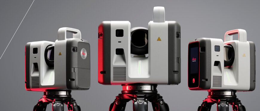
The launch of the all-new Leica RTC series — comprising the RTC300, 500, and 700 models — marks a major advancement in terrestrial laser scanning by combining high-speed data capture with industrial-grade precision. As modern surveying, engineering, and infrastructure projects face compressed schedules and expanding data volumes, transforming physical assets into precise spatial models requires rapid, automated workflows. This technology ensures that physical site metrics are immediately digitized and fed directly into the enterprise's digital supply chain for asset management and construction orchestration.
Scalable Performance Architecture and Hardware Integration
The new RTC series is designed to replace the existing Leica RTC360/LT and ScanStation P30/P40/P50Â product lines, bridging the gap between the rapid scanning speed of the RTC360Â and the structural robustness of the P-Series. This unified hardware platform delivers a 35% increase in data accuracy compared to its nearest market competitor, making it highly versatile for applications across surveying, industrial plants, public safety, and infrastructure projects.
A core feature of the RTC series is its upgradeable platform design, structured into three distinct performance tiers. Through this tiered scalability, engineering teams can purchase the specific performance level that matches their current project requirements and budget constraints. Furthermore, the system supports on-demand upgrades; as data complexity or range demands grow, users can transition to a higher performance tier via software-enabled unlocks, entirely eliminating the capital expense of replacing physical hardware.
Real-Time Cloud Collaboration and Livelink Connectivity
Beyond raw hardware metrics, the RTC series transforms data sharing from a sequential process into a continuous, real-time workflow. This shift is driven by Livelink, an industry-first capability integrated into the Leica Cyclone FIELD 360Â mobile application. Livelink automatically streams point cloud data directly to the Hexagon GeoCloud as it is captured by the sensor.
This cloud-connected ecosystem allows multiple laser scanners on a single job site to feed data into a unified, shared project simultaneously. Field crews and office-based BIM managers can visualize the registered data in real time, enabling them to identify and resolve data gaps or shadow zones before leaving the site. This immediate cloud synchronization provides an operational visibility model akin to an automotive data ecosystem, where edge-generated spatial data is continuously consolidated to streamline downstream design, manufacturing, and operational deliverables.
Additional Context: This section details technical specifications and competitive benchmarking not included in the original product announcement
In the terrestrial laser scanning (TLS) market, the Leica RTC series enters direct competition with high-precision systems like the Trimble X9 and X12, as well as the FARO Focus Premium series. Trimble's X-series differentiates itself through automatic calibration and self-leveling mechanics handled via Trimble Perspective software, while FARO emphasizes lightweight portability and direct synchronization with their Sphere cloud environment. Leica's competitive advantage with the RTC series relies on its 35% accuracy improvement and, crucially, its hardware-retaining upgrade path — a structural capability not currently mirrored by Trimble or FARO, where scaling up scanning capabilities typically mandates a complete hardware trade-in.
From a technical standpoint, managing high-density point clouds requires balancing angular accuracy, range noise, and data transmission bandwidth. The RTC series optimizes this through advanced wave-form digitizing or time-of-flight technology that maintains low range noise even at extended distances. When streaming raw data from the field via Livelink, transmitting full-resolution point clouds over cellular networks can hit bandwidth bottlenecks.
To circumvent this, Leica's architecture transmits lightweight preview packets and pre-registered cloud-to-cloud alignment matrices to the Hexagon GeoCloud first. This allows immediate quality assurance and gap detection in the office, while the heavy, uncompressed raw sensor measurements are indexed locally and uploaded in optimized background blocks, minimizing on-site cellular dependency and preventing data corruption.
Edited by Maria Brueva, Induportals editor – adapted by AI.
www.leica-geosystems.com
Powered by
Induportals Media Publishing