Leica launches CS50 field controller and Captivate 2027 software
The new surveying tools feature AI-RTK, visual stakeout, and rapid processing for handling large CAD datasets. leica-geosystems.com Leica Geosystems, part of Hexagon, has introduced the Leica CS50 field controller alongside the new Leica Captivate 2027 field software. These advanced tools are engineered to help professional surveyors manage massive datasets efficiently, maintain robust positioning in challenging environments, and execute point stakeouts with increased confidence. Optimized processing and visual stakeout As surveying workflows increasingly demand the handling of large CAD and IFC files directly on site, the CS50 field controller delivers fast processing capabilities on a multi-touch display coupled with a tactile, backlit keypad. Its rugged, ergonomic design allows for familiar one-handed operation while navigating complex digital models without lag. Accompanying the hardware, the Captivate 2027 software introduces camera-based GNSS visual stakeout capabilities. When paired with the Leica GS18 I smart antenna, this feature overlays stakeout points directly onto a live camera feed, visually guiding surveying crews to their precise targets with unprecedented speed. AI-RTK and cloud collaboration To combat signal disruption near buildings or dense vegetation, Captivate 2027 features AI-RTK for the Leica GS18. This artificial intelligence-driven function intelligently distinguishes reliable GNSS signals from those distorted by the environment, maintaining highly accurate positioning. Furthermore, the updated software establishes shared collaborative projects. By creating a unified data structure across Captivate, Leica Infinity, and Hexagon GeoCloud, field crews and office teams can seamlessly synchronize project files and settings. According to Hans-Martin Zogg, Head of Business Line Surveying at Hexagon’s Geomatics Division, this integrated approach turns AI capabilities and high-speed data connectivity into practical, everyday workflow benefits without disrupting the established skills of surveying professionals. Additional Context: Multipath errors and AI-RTK in GNSS surveying This section details GNSS signal dynamics and algorithmic filtering not included in the original press release. In high-precision GNSS (Global Navigation Satellite System) surveying, one of the most severe challenges is the "multipath effect." This occurs when satellite signals bounce off reflective surfaces—such as glass building facades, metallic structures, or wet tree canopies—before reaching the rover's antenna. Because the signal travels a longer, indirect path, the receiver miscalculates the time of flight, introducing significant positional errors. Traditional RTK (Real-Time Kinematic) algorithms often struggle to instantly identify these reflected signals in highly obstructed environments like urban canyons. AI-RTK tackles this limitation by deploying machine learning algorithms trained on vast datasets of signal behavior. Instead of relying solely on geometric signal-to-noise ratio cutoffs, the AI dynamically analyzes the waveform, frequency, and phase characteristics of incoming signals, rapidly isolating and rejecting multipath distortions to maintain centimeter-level accuracy even when the direct line of sight to the sky is partially blocked. Edited by an industrial journalist, Lekshman Ramdas, with AI assistance. www.leica-geosystems.com Powered by Induportals Media Publishing
 machineryasia

The new surveying tools feature AI-RTK, visual stakeout, and rapid processing for handling large CAD datasets.
leica-geosystems.com
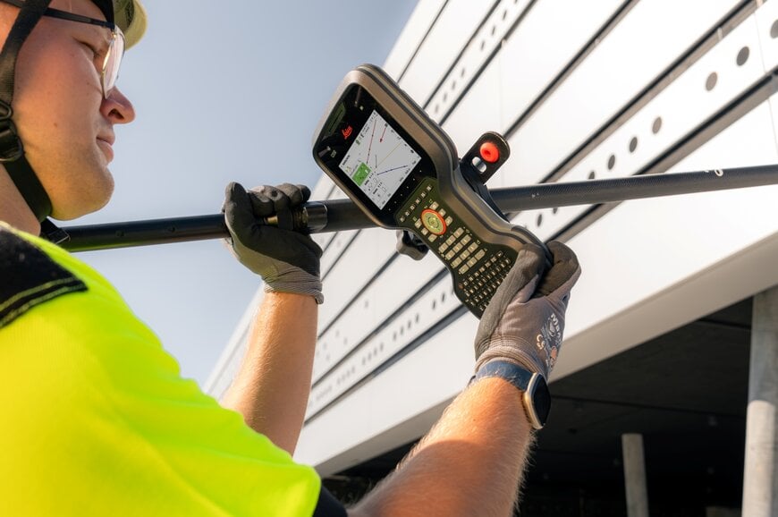
Leica Geosystems, part of Hexagon, has introduced the Leica CS50 field controller alongside the new Leica Captivate 2027 field software. These advanced tools are engineered to help professional surveyors manage massive datasets efficiently, maintain robust positioning in challenging environments, and execute point stakeouts with increased confidence.
Optimized processing and visual stakeout
As surveying workflows increasingly demand the handling of large CAD and IFC files directly on site, the CS50 field controller delivers fast processing capabilities on a multi-touch display coupled with a tactile, backlit keypad. Its rugged, ergonomic design allows for familiar one-handed operation while navigating complex digital models without lag. Accompanying the hardware, the Captivate 2027 software introduces camera-based GNSS visual stakeout capabilities. When paired with the Leica GS18 I smart antenna, this feature overlays stakeout points directly onto a live camera feed, visually guiding surveying crews to their precise targets with unprecedented speed.
AI-RTK and cloud collaboration
To combat signal disruption near buildings or dense vegetation, Captivate 2027 features AI-RTK for the Leica GS18. This artificial intelligence-driven function intelligently distinguishes reliable GNSS signals from those distorted by the environment, maintaining highly accurate positioning. Furthermore, the updated software establishes shared collaborative projects. By creating a unified data structure across Captivate, Leica Infinity, and Hexagon GeoCloud, field crews and office teams can seamlessly synchronize project files and settings. According to Hans-Martin Zogg, Head of Business Line Surveying at Hexagon’s Geomatics Division, this integrated approach turns AI capabilities and high-speed data connectivity into practical, everyday workflow benefits without disrupting the established skills of surveying professionals.
Additional Context: Multipath errors and AI-RTK in GNSS surveying
This section details GNSS signal dynamics and algorithmic filtering not included in the original press release.
In high-precision GNSS (Global Navigation Satellite System) surveying, one of the most severe challenges is the "multipath effect." This occurs when satellite signals bounce off reflective surfaces—such as glass building facades, metallic structures, or wet tree canopies—before reaching the rover's antenna. Because the signal travels a longer, indirect path, the receiver miscalculates the time of flight, introducing significant positional errors. Traditional RTK (Real-Time Kinematic) algorithms often struggle to instantly identify these reflected signals in highly obstructed environments like urban canyons. AI-RTK tackles this limitation by deploying machine learning algorithms trained on vast datasets of signal behavior. Instead of relying solely on geometric signal-to-noise ratio cutoffs, the AI dynamically analyzes the waveform, frequency, and phase characteristics of incoming signals, rapidly isolating and rejecting multipath distortions to maintain centimeter-level accuracy even when the direct line of sight to the sky is partially blocked.
Edited by an industrial journalist, Lekshman Ramdas, with AI assistance.
www.leica-geosystems.com
Powered by
Induportals Media Publishing