Hyundai Construction Equipment and Leica Geosystems Expand 3D Machine Control for HD130A Dozers
Leica MC1 3D is now available as an aftermarket upgrade, enabling advanced grading accuracy and digital workflows across Hyundai dozer fleets. leica-geosystems.com Hyundai Construction Equipment and Leica Geosystems are now providing the Leica MC1 3D machine guidance system as an aftermarket solution for the Hyundai HD130A series dozers. This cooperation targets the heavy construction and earthmoving industries, aiming to integrate advanced machine control directly into existing digital infrastructure. Addressing Grading Accuracy Challenges The partnership between Hyundai Construction Equipment, an earthmoving machinery manufacturer, and Leica Geosystems, a developer of measurement and surveying solutions, addresses the technical challenge of achieving precise grading accuracy on construction sites. The cooperation utilizes Hyundai's heavy machinery platforms and Leica Geosystems' positioning technology to establish a system that reduces material waste and the necessity for subsequent rework. System Architecture and Configuration The Leica MC1 3D machine control system provides machinery operators with real-time cut and fill guidance generated from digital design models. The aftermarket kit supports multiple technical setups, accommodating all 2D and 3D dozer configurations. Supported hardware architectures include on-cab setups, dual laser systems, total positioning stations, and dual Global Navigation Satellite System on-blade configurations. Leica Geosystems provides the positioning software and guidance ecosystem, while Hyundai facilitates the mechanical and electrical compatibility required for the HD130A dozer models. Aftermarket Implementation and Digital Integration The machine guidance system is implemented as an aftermarket retrofit. The installation utilizes established service networks to equip the dozers with plug-and-play components, minimizing downtime during the upgrade process. This integration allows the machinery to interface with established networks, including Leica ConX, a cloud-based collaboration platform used for remote site management and spatial data exchange. Earthmoving Operations and Efficiency Deployed primarily in civil construction and site preparation, the system is used for precise material levelling and surface grading. Technical use cases include continuous monitoring of the dozer blade position relative to uploaded site models. This mechanism improves operational stability by allowing operators to reach the specified grade in fewer passes, which directly lowers fuel consumption and minimizes mechanical wear on the equipment. Operational Impact The integration reduces reliance on manual field surveying and manual estimation. By transmitting continuous spatial data directly to the operator interface in the cabin, the system ensures consistent grading accuracy and streamlines the data flow between site management personnel and machine operators. Edited by Natania Lyngdoh, Induportals editor, assisted by AI. www.leica-geosystems.com Powered by Induportals Media Publishing
 machineryasia
Leica MC1 3D is now available as an aftermarket upgrade, enabling advanced grading accuracy and digital workflows across Hyundai dozer fleets.
leica-geosystems.com
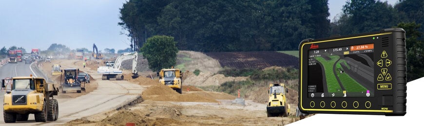
Hyundai Construction Equipment and Leica Geosystems are now providing the Leica MC1 3D machine guidance system as an aftermarket solution for the Hyundai HD130A series dozers. This cooperation targets the heavy construction and earthmoving industries, aiming to integrate advanced machine control directly into existing digital infrastructure.
Addressing Grading Accuracy Challenges
The partnership between Hyundai Construction Equipment, an earthmoving machinery manufacturer, and Leica Geosystems, a developer of measurement and surveying solutions, addresses the technical challenge of achieving precise grading accuracy on construction sites. The cooperation utilizes Hyundai's heavy machinery platforms and Leica Geosystems' positioning technology to establish a system that reduces material waste and the necessity for subsequent rework.
System Architecture and Configuration
The Leica MC1 3D machine control system provides machinery operators with real-time cut and fill guidance generated from digital design models. The aftermarket kit supports multiple technical setups, accommodating all 2D and 3D dozer configurations. Supported hardware architectures include on-cab setups, dual laser systems, total positioning stations, and dual Global Navigation Satellite System on-blade configurations. Leica Geosystems provides the positioning software and guidance ecosystem, while Hyundai facilitates the mechanical and electrical compatibility required for the HD130A dozer models.
Aftermarket Implementation and Digital Integration
The machine guidance system is implemented as an aftermarket retrofit. The installation utilizes established service networks to equip the dozers with plug-and-play components, minimizing downtime during the upgrade process. This integration allows the machinery to interface with established networks, including Leica ConX, a cloud-based collaboration platform used for remote site management and spatial data exchange.
Earthmoving Operations and Efficiency
Deployed primarily in civil construction and site preparation, the system is used for precise material levelling and surface grading. Technical use cases include continuous monitoring of the dozer blade position relative to uploaded site models. This mechanism improves operational stability by allowing operators to reach the specified grade in fewer passes, which directly lowers fuel consumption and minimizes mechanical wear on the equipment.
Operational Impact
The integration reduces reliance on manual field surveying and manual estimation. By transmitting continuous spatial data directly to the operator interface in the cabin, the system ensures consistent grading accuracy and streamlines the data flow between site management personnel and machine operators.
Edited by Natania Lyngdoh, Induportals editor, assisted by AI.
www.leica-geosystems.com
Powered by
Induportals Media Publishing