Augmented Reality and Photogrammetry Integrate Everyday Surveying Workflows
Leica Geosystems expands field surveying infrastructure by introducing image-assisted positioning and standardized data transfer workflows for civil engineering and spatial data collection. leica-geosystems.com Hexagon division Leica Geosystems announced an integrated survey architecture linking field software, GNSS receivers, total stations, and cloud processing services for operational surveying and construction staking. The platform directly targets routine geomatics, civil infrastructure projects, and utility mapping, providing simplified field-to-finish data flows for field crews with varying technical experience. Integrated Visual Positioning and Survey Software Architecture Field workflows often encounter efficiency losses during point stakeout and remote point acquisition where direct pole placement is hazardous or physically obstructed. To mitigate these conditions, the suite pairs the Leica GS11 GNSS smart antenna with Leica X-PAD software to introduce augmented reality visualization and close-range photogrammetry to routine field tasks. By projecting stakeout vectors, design surfaces, and Building Information Modeling (BIM) data directly onto a real-time video feed, the system guides operators to target coordinates without relying solely on traditional directional compass screens. The image-based measurement module captures geo-referenced photographic sets. Field operators extract spatial coordinates directly from the imagery, permitting non-contact measurement of inaccessible structural assets, overhead lines, and open excavations. In-field graphical verification confirms feature capture density prior to site demobilization, reducing repeat visits. Hardware Interoperability and Cloud Synchronization The system operates across a defined instrument ecosystem, functioning with the Leica GS11 antenna, the compact Leica GS05 GNSS receiver, and the Leica TS13 robotic total station. Point collection supports two-dimensional, three-dimensional, digital terrain model, and BIM project layers. Data flows to Leica X-PAD Fusion office software via Hexagon GeoCloud services, while network positioning corrections route through the Hexagon SmartNet GNSS infrastructure. The platform relies on software architecture derived from Hexagon subsidiary GeoMax, which maintains uninterrupted hardware support, instrument distribution, and partner channel servicing alongside the unified release. Commercial distribution commences in select global regions in 2026, expanding broadly across international markets in 2027. Additional Context This section details technical specifications and competitive benchmarking not included in the original product announcement. Image-assisted GNSS technology relies on the integration of multi-frequency GNSS tracking, visual-inertial odometry (VIO), and calibrated complementary metal-oxide-semiconductor (CMOS) cameras. In the visual GNSS sector, primary commercial equivalents include the Leica GS18 I and the Trimble R12i/Trimble Catalyst visual workflows. The Leica GS18 I captures dense point clouds through continuous photogrammetry calibrated with an inertial measurement unit (IMU), functioning as a primary survey-grade instrument for complex geodetic engineering. The GS11 implementation under X-PAD targets point-and-click image coordinate measurement and augmented reality overlays rather than continuous dense point cloud generation, optimizing computing overhead for standard field controllers. In terms of visual guidance, comparable architectures include the Trimble SiteVision outdoor augmented reality system and the Topcon HiPer VR GNSS receiver paired with field software. While SiteVision relies on consumer mobile hardware integrated with external correction receivers, the GS11 packages the imaging sensor and GNSS processing engine into a dedicated smart antenna housing. This self-contained architecture ensures fixed optical calibration relative to the phase center of the antenna, maintaining consistent spatial offsets during visual coordinate extraction. Edited by Evgeny Churilov, Induportals Media - Adapted by AI. www.leica-geosystems.com Powered by Induportals Media Publishing
 machineryasia
Leica Geosystems expands field surveying infrastructure by introducing image-assisted positioning and standardized data transfer workflows for civil engineering and spatial data collection.
leica-geosystems.com
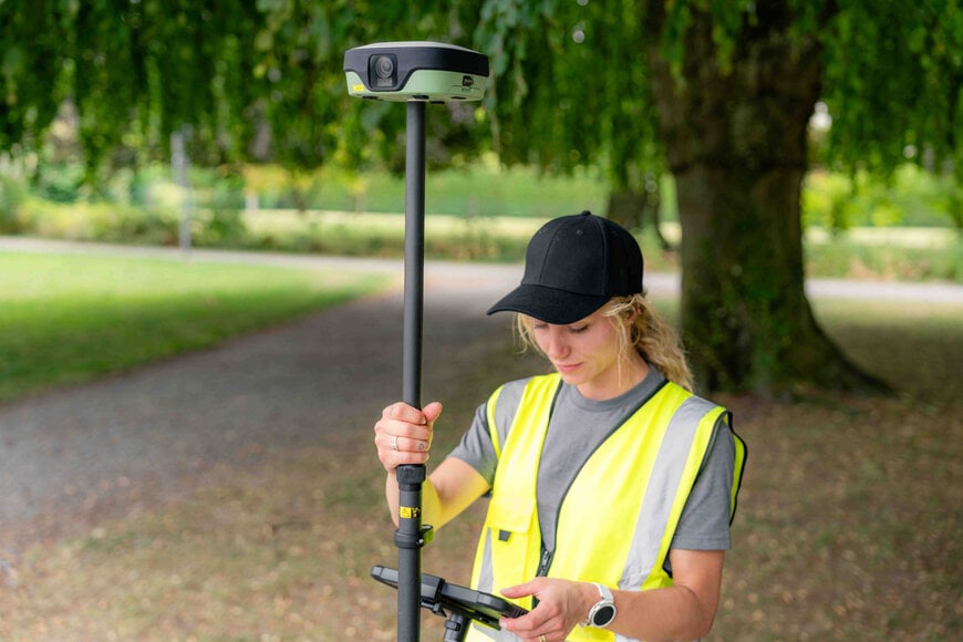
Hexagon division Leica Geosystems announced an integrated survey architecture linking field software, GNSS receivers, total stations, and cloud processing services for operational surveying and construction staking. The platform directly targets routine geomatics, civil infrastructure projects, and utility mapping, providing simplified field-to-finish data flows for field crews with varying technical experience.
Integrated Visual Positioning and Survey Software Architecture
Field workflows often encounter efficiency losses during point stakeout and remote point acquisition where direct pole placement is hazardous or physically obstructed. To mitigate these conditions, the suite pairs the Leica GS11 GNSS smart antenna with Leica X-PAD software to introduce augmented reality visualization and close-range photogrammetry to routine field tasks. By projecting stakeout vectors, design surfaces, and Building Information Modeling (BIM) data directly onto a real-time video feed, the system guides operators to target coordinates without relying solely on traditional directional compass screens.
The image-based measurement module captures geo-referenced photographic sets. Field operators extract spatial coordinates directly from the imagery, permitting non-contact measurement of inaccessible structural assets, overhead lines, and open excavations. In-field graphical verification confirms feature capture density prior to site demobilization, reducing repeat visits.
Hardware Interoperability and Cloud Synchronization
The system operates across a defined instrument ecosystem, functioning with the Leica GS11 antenna, the compact Leica GS05 GNSS receiver, and the Leica TS13 robotic total station. Point collection supports two-dimensional, three-dimensional, digital terrain model, and BIM project layers.
Data flows to Leica X-PAD Fusion office software via Hexagon GeoCloud services, while network positioning corrections route through the Hexagon SmartNet GNSS infrastructure. The platform relies on software architecture derived from Hexagon subsidiary GeoMax, which maintains uninterrupted hardware support, instrument distribution, and partner channel servicing alongside the unified release. Commercial distribution commences in select global regions in 2026, expanding broadly across international markets in 2027.
Additional Context
This section details technical specifications and competitive benchmarking not included in the original product announcement.
Image-assisted GNSS technology relies on the integration of multi-frequency GNSS tracking, visual-inertial odometry (VIO), and calibrated complementary metal-oxide-semiconductor (CMOS) cameras.
In the visual GNSS sector, primary commercial equivalents include the Leica GS18 I and the Trimble R12i/Trimble Catalyst visual workflows. The Leica GS18 I captures dense point clouds through continuous photogrammetry calibrated with an inertial measurement unit (IMU), functioning as a primary survey-grade instrument for complex geodetic engineering. The GS11 implementation under X-PAD targets point-and-click image coordinate measurement and augmented reality overlays rather than continuous dense point cloud generation, optimizing computing overhead for standard field controllers.
In terms of visual guidance, comparable architectures include the Trimble SiteVision outdoor augmented reality system and the Topcon HiPer VR GNSS receiver paired with field software. While SiteVision relies on consumer mobile hardware integrated with external correction receivers, the GS11 packages the imaging sensor and GNSS processing engine into a dedicated smart antenna housing. This self-contained architecture ensures fixed optical calibration relative to the phase center of the antenna, maintaining consistent spatial offsets during visual coordinate extraction.
Edited by Evgeny Churilov, Induportals Media - Adapted by AI.
www.leica-geosystems.com
Powered by
Induportals Media Publishing