3D Grade Control Systems for Excavator Automation
Trimble introduces a dual DA2 GNSS receiver configuration for its Trimble Earthworks platform to reduce upfront hardware costs for civil construction contractors. www.trimble.com Small- and medium-sized earthmoving contractors adopting automated machine guidance frequently face high capital expenditures and signal reliability challenges in obstructed excavation environments. To lower the financial threshold for transitioning from manual staking or 2D laser guidance to spatial automation, Trimble has released a new configuration of its Trimble Earthworks grade control platform for excavators utilizing dual DA2 global navigation satellite system receivers across civil construction and earthmoving applications. Overcoming Capital and Signal Multipath Constraints in Earthmoving Traditional excavation workflows rely on manual grade checking and physical survey stakes, which expose ground personnel to active machinery hazards and lead to material over-excavation or rework when design tolerances are missed. While 3D machine control eliminates manual staking by comparing real-time bucket positions against digital terrain models, the initial investment required for ruggedized dual-antenna satellite hardware has historically restricted fleet-wide adoption among smaller earthmoving operations. In addition to procurement costs, satellite-based machine guidance must contend with signal degradation caused by tree canopies, urban structures, and steep trench walls. Maintaining consistent horizontal and vertical accuracy under these conditions requires advanced signal filtering capable of tracking multiple satellite constellations simultaneously without experiencing positioning dropouts that halt machine productivity. Dual GNSS Architecture and Positioning Engine Mechanics The updated excavator configuration pairs the Trimble Earthworks software environment with two cab-mounted DA2 global navigation satellite system receivers. Using a dual-receiver architecture on an excavator is essential for calculating real-time 3D heading and pitch orientation while the machine remains stationary. Unlike single-antenna systems that require forward machine travel to determine kinematic heading, dual antennas establish a fixed baseline vector across the counterweight or cab roof, allowing the system to orient the boom, stick, and bucket cutting edge relative to the digital design model at all times. At the core of the receiver architecture is the Trimble ProPoint positioning engine. This signal-processing engine integrates multi-constellation satellite measurements to maintain positioning accuracy in challenging environments where signal multipath and partial sky obstruction typically degrade traditional real-time kinematic solutions. Integrating Field-to-Office Data Workflows and Fleet Deployment Beyond on-machine positioning, modern civil construction workflows require continuous synchronization between engineering design teams and field operators. When site engineering blueprints are revised, operating heavy equipment against outdated design files results in costly grading errors. The DA2 configuration integrates directly with the Trimble WorksManager software platform, which manages wireless data transfer between the office and the field. This connectivity ensures that updated 3D surface models and project parameters are pushed remotely to the excavator cab, connecting project stakeholders with current operational data. To address capital expenditure constraints, the hardware and software package is delivered through a Trimble Works subscription model, with commercial availability scheduled for the middle of the fourth quarter of 2026 via the global dealer network. Cameron Clark, senior director of earthmoving solutions at Trimble, noted that because every minute of machine downtime or degraded positioning performance results in lost revenue for contractors, offering a full 3D machine control system via subscription allows cost-sensitive operations to adopt spatial technology earlier and scale deployments across multiple machines without compromising precision. Additional Context: This section details technical specifications and competitive benchmarking not included in the original product announcement. In automated earthmoving and civil engineering, 3D excavator grade control systems combine global navigation satellite system receivers with inertial measurement units mounted on the machine body, boom, stick, and bucket. While the dual satellite antennas establish the global position and heading of the excavator house in local site coordinates, solid-state inertial sensors measure the angular tilt and kinematic motion of the hydraulic linkage. In standard real-time kinematic operations, dual-GNSS grade control architectures typically achieve vertical and horizontal positioning accuracies within 10 to 30 millimeters, compared to several centimeters or decimeters for uncorrected satellite navigation. The underlying Trimble
 machineryasia

Trimble introduces a dual DA2 GNSS receiver configuration for its Trimble Earthworks platform to reduce upfront hardware costs for civil construction contractors.
www.trimble.com
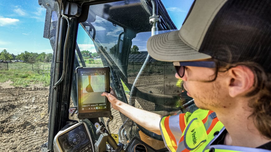
Small- and medium-sized earthmoving contractors adopting automated machine guidance frequently face high capital expenditures and signal reliability challenges in obstructed excavation environments. To lower the financial threshold for transitioning from manual staking or 2D laser guidance to spatial automation, Trimble has released a new configuration of its Trimble Earthworks grade control platform for excavators utilizing dual DA2 global navigation satellite system receivers across civil construction and earthmoving applications.
Overcoming Capital and Signal Multipath Constraints in Earthmoving
Traditional excavation workflows rely on manual grade checking and physical survey stakes, which expose ground personnel to active machinery hazards and lead to material over-excavation or rework when design tolerances are missed. While 3D machine control eliminates manual staking by comparing real-time bucket positions against digital terrain models, the initial investment required for ruggedized dual-antenna satellite hardware has historically restricted fleet-wide adoption among smaller earthmoving operations.
In addition to procurement costs, satellite-based machine guidance must contend with signal degradation caused by tree canopies, urban structures, and steep trench walls. Maintaining consistent horizontal and vertical accuracy under these conditions requires advanced signal filtering capable of tracking multiple satellite constellations simultaneously without experiencing positioning dropouts that halt machine productivity.
Dual GNSS Architecture and Positioning Engine Mechanics
The updated excavator configuration pairs the Trimble Earthworks software environment with two cab-mounted DA2 global navigation satellite system receivers. Using a dual-receiver architecture on an excavator is essential for calculating real-time 3D heading and pitch orientation while the machine remains stationary. Unlike single-antenna systems that require forward machine travel to determine kinematic heading, dual antennas establish a fixed baseline vector across the counterweight or cab roof, allowing the system to orient the boom, stick, and bucket cutting edge relative to the digital design model at all times.
At the core of the receiver architecture is the Trimble ProPoint positioning engine. This signal-processing engine integrates multi-constellation satellite measurements to maintain positioning accuracy in challenging environments where signal multipath and partial sky obstruction typically degrade traditional real-time kinematic solutions.
Integrating Field-to-Office Data Workflows and Fleet Deployment
Beyond on-machine positioning, modern civil construction workflows require continuous synchronization between engineering design teams and field operators. When site engineering blueprints are revised, operating heavy equipment against outdated design files results in costly grading errors. The DA2 configuration integrates directly with the Trimble WorksManager software platform, which manages wireless data transfer between the office and the field. This connectivity ensures that updated 3D surface models and project parameters are pushed remotely to the excavator cab, connecting project stakeholders with current operational data.
To address capital expenditure constraints, the hardware and software package is delivered through a Trimble Works subscription model, with commercial availability scheduled for the middle of the fourth quarter of 2026 via the global dealer network. Cameron Clark, senior director of earthmoving solutions at Trimble, noted that because every minute of machine downtime or degraded positioning performance results in lost revenue for contractors, offering a full 3D machine control system via subscription allows cost-sensitive operations to adopt spatial technology earlier and scale deployments across multiple machines without compromising precision.
Additional Context:
This section details technical specifications and competitive benchmarking not included in the original product announcement.
In automated earthmoving and civil engineering, 3D excavator grade control systems combine global navigation satellite system receivers with inertial measurement units mounted on the machine body, boom, stick, and bucket. While the dual satellite antennas establish the global position and heading of the excavator house in local site coordinates, solid-state inertial sensors measure the angular tilt and kinematic motion of the hydraulic linkage. In standard real-time kinematic operations, dual-GNSS grade control architectures typically achieve vertical and horizontal positioning accuracies within 10 to 30 millimeters, compared to several centimeters or decimeters for uncorrected satellite navigation.
The underlying Trimble ProPoint engine represents a fifth-generation real-time kinematic and precise point positioning signal processor designed to simultaneously track GPS, GLONASS, Galileo, BeiDou, and QZSS constellations. In independent survey and machine control benchmarks, modern multi-constellation engines improve convergence times and positioning availability near heavy foliage or urban canyons by more than 30 percent compared to legacy GPS-plus-GLONASS architectures, which require a minimum of five common satellites from a single or dual constellation to maintain a fixed solution.
Across the heavy construction technology sector, tiered subscription-based hardware configurations have become a primary mechanism for expanding 3D machine control into mid-tier fleets. Comparable architectural approaches include Topcon Positioning Systems MC-Mobile and MC-Max platforms, as well as Leica Geosystems iCON iXE3 excavator systems. While flagship dual-GNSS configurations utilizing heavy-duty modular receivers such as the Trimble MS995 or Leica iCON gps 80 are engineered for high-vibration mining and heavy dozer blade mounting, utilizing lighter cab-mounted smart antennas like the DA2 allows manufacturers to lower hardware complexity on excavators, where the antennas are isolated from direct ground-engaging impact loads.
Edited by Sucithra Mani, Induportals editor – adapted by AI.
www.trimble.com
Powered by
Induportals Media Publishing